Coseismic Uplift and Subsidence: An underappreciated seismic threat
Richard Styron
Earthquakes on dip-slip faults can produce land level changes that may last decades to millenia. Much of the time this is relatively harmless, but in coastal environments, the effects may be damaging.
Though violent ground shaking dominates our imaginations when we think of the effects of earthquakes, geologists often consider the ground displacement on either side of the causative fault to be the primary effect.
In the time between major earthquakes on a fault (the interseismic period), the crust on either side of the fault moves slowly in the direction of long-term tectonic motion, but the displacement is not localized at the fault surface; the profile of displacement across the fault is smooth.
During an earthquake (the coseismic period), this trend is reversed. The crust on either side of the fault moves very rapidly with respect to the other side. This displacement is permanent; it is not a transitory phenomenon such as ground shaking. The displacements are highest near the fault (with a major step or offset at the fault scarp) and then decrease asympototically to zero with distance from the fault.
Figure 1: GEM Hazard Scientist Kendra Johnson at a fault scarp from the 2016 Norcia and Amatrice earthquakes in Central Italy. Photo credit: R. Styron
Many major faults on land are strike-slip faults. In this case, the interseismic and coseismic displacements are essentially horizontal, except for where geometric irregularities in the fault produce localized, irregular vertical displacements. Though this deformation may sever infrastructure along the fault, the primary damage away from the fault is from ground shaking rather than permanent displacements.
However, tectonic activity along inclined, dip-slip faults has a primarily vertical signature (uplift or subsidence). As with a strike-slip fault, the largest displacement of the Earth's surface is right at the fault trace (assuming the fault ruptures to the surface), and the displacement generally decreases with distance from the fault.
The displacement profile is somewhat more complicated. Some areas will be uplifted and some will subside, based not on their distance from the fault trace, but from the surface projection of the lower edge of fault locking.
For the most part, uplift or subsidence will be relatively minor for moderate-magnitude events (a few cm perhaps), and unlikely to cause great harm.
However, during a great subduction zone earthquake, the coastline may rise or fall by a considerable amount, which can expose or inundate coastal areas. Let's consider a scenario earthquake on a simplified version of the Middle America Trench of the Nicaraguan coast to further evaluate the geometry and magnitude of the uplift and subsidence.
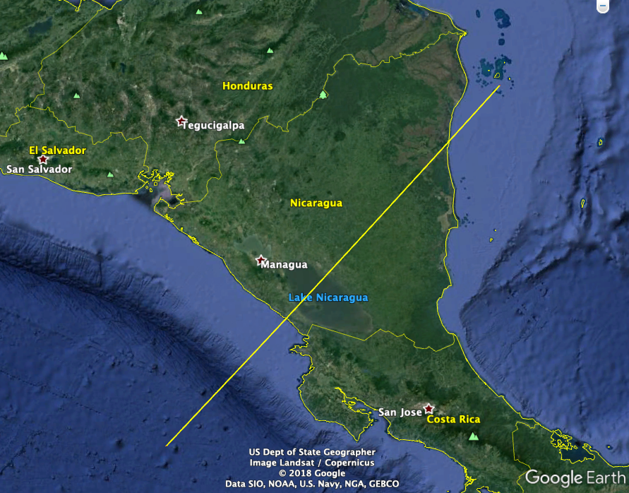
 Figure 2: Google Earth image of Nicaragua showing location of profile in
yellow line. The profile crosses the coast at the town of San Juan del Sur.
Figure 2 shows an image of Nicaragua from Google Earth. In this image, the Middle America Trench (a subduction zone) is clear to the southwest of the country. A bathymetric and topographic profile has been drawn across the map, which crosses onto the Pacific coast at the sleepy beach town of San Juan del Sur.

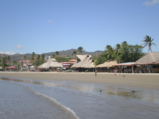
Figure 3: The lovely beach at San Juan del Sur, Nicaragua. Photo credit: Bronson Harrington.
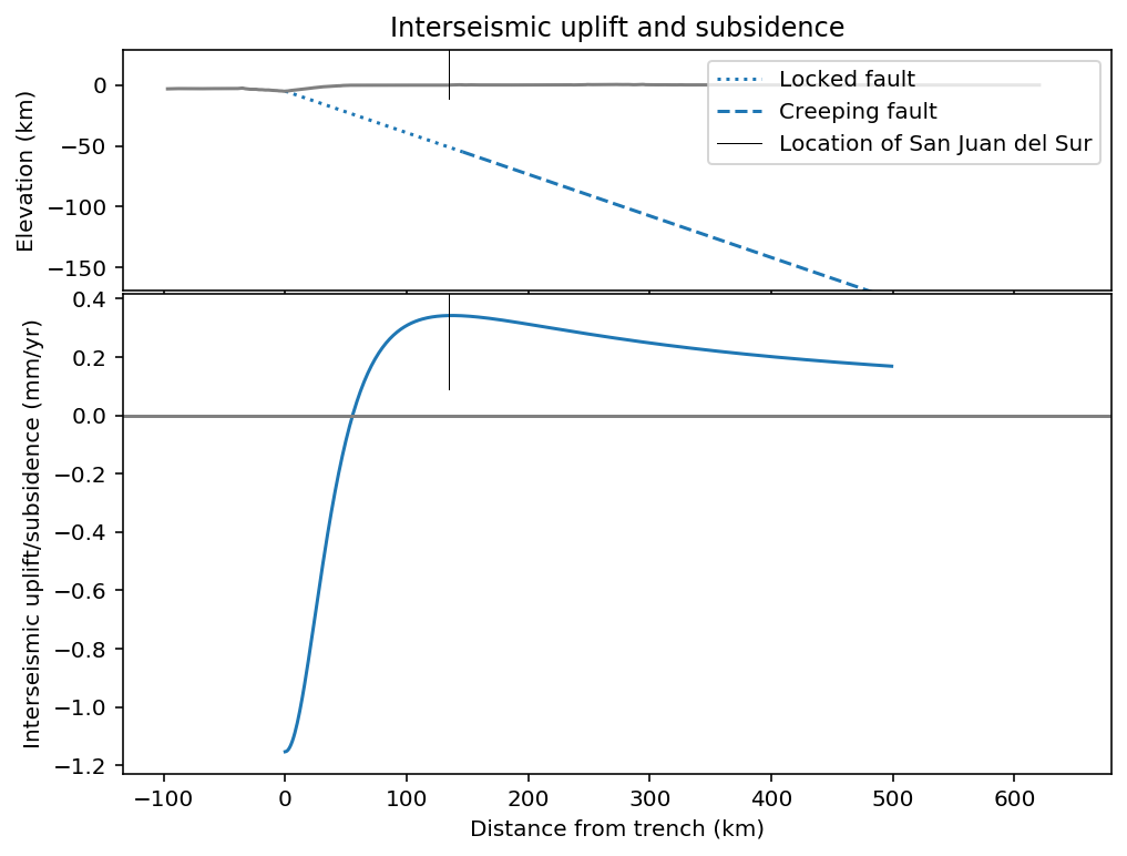
Subduction of the Cocos plate at about 90 mm/yr beneath the Central American crust occurs at the Middle America Trench here. During the interseismic period, the subduction megathrust is locked and accumulates elastic energy. (In reality, subduction here may only be partially locked, but we will ignore that for this example.) We will consider here that the megathrust dips 20 degrees to the northwest, and is locked to 50 km depth (Figure 4).
Figure 4: Interseismic vertical displacements from subduction zone locking. The top subfigure is an idealized cross-section through the crust. The surface of the Earth is shown in a grey line, and the subduction zone in blue. The bottom subfigure shows the vertical displacement rate due to steady creep below the locked zone. San Juan del Sur's location in the profile is shown as a thin vertical black line on both subfigures.
During the interseismic period, steady creep of the subduciton zone below 50 km depth, and locking above, causes the earth's surface near the trench to subside. However, farther into the overriding plate, there is a reversal of the sign of displacement, and the area near the coast actually undergoes uplift of up to ~0.3 mm/yr. This is not very rapid and is essentially undetectable without very precise geodetic instrumentation.
Unfortunately, though, what goes up must come down.
During a great subduction zone earthquake, the portion of the subduction zone that was previously locked slips rapidly. In addition to the tremendous ground shaking and probable tsunami generated, the areas that were previously uplifting very slowly will drop. This happens near-instantaneously.
Figure 5: Coseismic uplift and subsidence.
Figure 5 demonstrates an idealized displacement of 18 m, which is 200 years of strain accumulation released in a single earthquake lasting minutes.
The areas offshore closest to the trench are uplifted by up to 2 meters. About 60-70 km inboard, though, there is a transition from uplift to subsidence. The maximum subsidence is very close to San Juan del Sur, and is greater than 60 cm.
60 cm of subsidence of the coast is essentially a local sea level rise of 60 cm. This change is persistent over decades (reversing slowly at a rate of 0.3 mm/yr on average, though a more sophisticated example may have time-dependent recovery rates). This amount of relative sea level change is quite dramatic.
First, an earthquake of this magnitude would produce a damaging tsunami, which would hit soon after the subsidence. The subsidence directly increases the amount of inundation and the distance inland the tsunami will reach.
After the earthquake, the coastline will be commensurately farther inland, and extant infrastructure will be more vulnerable to coastal flooding, damaging waves during storm events, coastal erosion, and other coastal hazards.
It is also important to note that this is not a localized effect; great subduction zone earthquakes extend for hundreds to well over a thousand kilometers, and the coastal deformation would stretch this length.
During the largest earthquakes, the subsidence can be even greater; Atwater et al., (2005) report that during the 1960 Chile earthquake, subsidence was up to 2 m.
The patterns of coastal subsidence may also alter patterns of coastal sedimentation. Portage, Alaska was famously dropped below sea level during the great 1964 earthquake, flooding the town and leaving a standing 'ghost forest' of dead trees (side note: George Plafker's analysis of the areas of uplift and subsidence allowed him to recognize that a huge dipping fault offshore was responsible, which was a fundamental insight that helped bring about the plate tectonics revolution). In the decades following the 1964 event, the very high sedimentation rates in the Cook Inlet blanketed the newly submerged area, filling it in with up to 1.5 m of tidal sediment, though the town and forest have not been revived (Figure 6).
Figure 6: Indundation and sedimentation at Portage, Alaska, following the 1964 earthquake. From Atwater et al., 2005.


